











More than 6,000 people were evacuated in West Bengal’s Alipurduar district after a glacial lake outburst in Bhutan triggered flash-flood warnings across parts of Assam and West Bengal. Although the situation has since shown signs of improvement, the incident has brought renewed attention to the threat posed by glacial lakes in the eastern Himalayas, where a sudden release of water can put communities and infrastructure far downstream at risk.
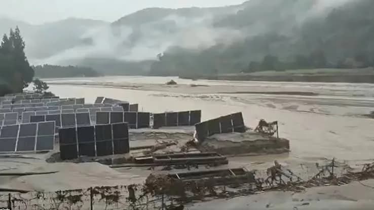
The incident occurred on Thursday at Shintaphu Lake in Bhutan’s Gasa district. The gush of water washed away facilities at Gasa Tshachu, a popular natural hot spring near the Mo Chhu River. No casualties were reported in Bhutan.
The authorities in West Bengal moved residents from vulnerable riverbank and forest areas to safer locations amid concerns about rising water levels along the Sankosh River. Jalpaiguri was also placed on high alert. Officials later said the water level had receded and there was no major damage or loss of life.
A glacial lake outburst flood (GLOF) occurred at Shintaphu Lake (also reported near the Lemthang/Lim Tang region) in the Gasa district of northwestern Bhutan on Thursday evening, October 29, 2026. #Key Details of the Incident * Location: Shintaphu Lake (below Wakila Mountain in the Lungo area of Laya Gewog, Gasa district) at the source of the Mo Chhu River. * Water Volume Released: Roughly 7.4 million cubic metres of water rushed into the river system. * Casualties: No loss of life or injuries have been reported, as local authorities evacuated vulnerable areas beforehand. * Impact in Bhutan: * Facilities at Gasa Tshachu (a natural hot spring near the Mo Chhu River) were completely washed out. * At least two Bailey bridges collapsed. * Floodwaters reached the PHPA-II dam reservoir, which had all its sluice gates opened and was completely empty. * Road infrastructure such as the Laya road suffered washouts. # Downstream Alerts & Warnings * India (West Bengal and Assam): Bhutanese authorities alerted India as swollen waters flow via the Mo Chhu and Pho Chhu * Affected / Alerted Regions: * West Bengal: High alerts have been issued in the Darjeeling hills, Terai, and Dooars regions—including Kumargram in Alipurduar district, Jalpaiguri district, and areas along the Sankosh River in Cooch Behar. * Assam: Vigilance and flash-flood warnings have been sounded in Dhubri and Kokrajhar districts. Source : media
— Saheli (@Saheli350137) October 30, 2026
Bhutan has 567 glacial lakes, 17 classified as dangerous
Bhutan’s mountainous landscape, glaciers and steep river valleys make it vulnerable to glacial lake outburst floods (GLOFs). According to the country’s National Centre for Hydrology and Meteorology, Bhutan has 567 glacial lakes, of which 17 are classified as potentially dangerous.
An earlier assessment had identified 25 such lakes, but subsequent investigations lowered the number to 17 after eight were found to pose relatively lower risks. The classification does not mean an outburst is imminent. The danger associated with each lake depends on factors such as the volume of water it holds, the condition of its natural barriers and the communities and infrastructure located downstream.
What is a Glacial Lake Outburst Flood?
Glacial lakes develop when retreating glaciers leave behind depressions that fill with meltwater. In many cases, the water is contained by natural barriers made of loose rocks, sediment and glacial debris, known as moraines.
These barriers can weaken or collapse following landslides, avalanches, heavy rainfall or rapid melting. When a large volume of water escapes suddenly, it can carry rocks and debris through mountain valleys, causing extensive destruction. This phenomenon is known as a glacial lake outburst flood.
The United Nations Development Programme (UNDP) describes GLOFs as a “tsunami in the sky”, underlining the scale of destruction they can cause.
This is what a GLOF looks like in motion: a Glacial Lake Outburst Flood, sometimes called a Jökulhlaup (Icelandic for "glacier run"). Basically: meltwater builds up in a basin trapped against or beneath a glacier. Eventually the ice dam gives way, and all that pent-up water rushes out; sometimes over the course of a day or more. At Columbia Glacier, this happens almost like clockwork, roughly once a year, with the lake taking about a day and a half to fully drain. No roads, no homes in the path; so it mostly happens quietly, without anyone downstream even noticing. Compare that to Juneau, where GLOFs along the Mendenhall River actually threaten homes and residents in the valley each year. Serious flood-mitigation work has gone into protecting the community there. Watching that volume of water suddenly break free from under a glacier is still humbling. Glaciers aren’t the frozen, unmoving things people picture. They’re alive, shifting, releasing; a reminder that even "solid" landscapes are anything but static. Prayers for Nepal #Nepal #FloodVideo
— Manisha Singh (@ManiYogini) August 26, 2026
Thorthormi And Raphstreng among closely monitored lakes
The Thorthormi and Raphstreng lakes in Bhutan’s Lunana region have drawn particular attention from researchers. A 2023 study published in the Journal of Hydrology examined four potentially dangerous lakes: Bechung Tsho, Raphstreng Tsho, Thorthormi Tsho and Lugge Tsho.
Also Read | West Bengal SIR appeals: Aadhaar authentication delays tribunal orders
The researchers modelled possible outburst scenarios, with estimated flood volumes ranging from 600,000 cubic metres to 300 million cubic metres. Their findings indicated that more than 16,000 people and infrastructure located up to 150 km downstream could be exposed under the scenarios studied. These figures represent modelled risks, not predictions of an imminent breach.
🚨⚠️ FLASH FLOOD ALERT | BHUTAN TO INDIA 🇧🇹🇮🇳 Reports of a Glacial Lake Outburst Flood (GLOF) at Shintaphu Lake in Bhutan have raised serious concerns about potential flash flooding downstream. 🌊 Massive volumes of water and debris are reportedly moving through the Mo Chu river system towards the Sankosh River basin, raising concerns for downstream areas. 🔴 AREAS UNDER CONCERN: – West Bengal: Alipurduar, Jalpaiguri and Cooch Behar. – Assam: Kokrajhar and Dhubri. ⚠️ URGENT SAFETY ADVISORY: – Residents near riverbanks should remain alert and follow official evacuation instructions. – Move to higher ground if authorities issue warnings. – Stay away from riverbanks, bridges and flooded roads. – Keep emergency supplies ready. 🙏 A serious reminder: Flash floods can strike with little warning. Stay vigilant, stay informed and follow updates from local administrations and disaster management authorities. #Bhutan #GLOF #GlacialLakeOutburst #FlashFloodAlert #NorthBengal #Assam #SankoshRiver #DisasterAlert
— @VijayBharat (@shikhar711) October 30, 2026
Bhutan’s history of glacial lake floods
Bhutan has experienced several GLOF events over the decades. On October 6, 1994, the partial collapse of the moraine dam at Lugge Tsho triggered a devastating flood that killed around 21 people and damaged homes, farmland and infrastructure.
A 2024 study published in Natural Hazards and Earth System Sciences also referred to GLOF events involving Tshojo Lake in 2009 and Lemthang Tsho in 2015. Researchers have documented at least 18 such events in Bhutan since the 1950s, although historical records are incomplete.
Climate change and the growing Himalayan risk
Rising temperatures are accelerating glacier retreat across the Himalayas, contributing to the formation of new glacial lakes and the expansion of existing ones. Warming can also weaken mountain slopes and permafrost, raising the risk of landslides and avalanches entering lakes. Climate change, however, does not automatically cause a GLOF. The condition of individual lakes and their surrounding terrain remains crucial.
Bhutan has been strengthening monitoring and early warning systems through satellite observations, field assessments and river-level monitoring. Timely warnings remain essential for communities living along downstream valleys.
Over 6,000 evacuated in Alipurduar as situation eases
In West Bengal, district authorities relocated more than 6,000 people from vulnerable areas and arranged shelter for thousands in local schools. Superintendent of Police Amit Kumar Shaw said, “We have safely relocated over 6,000 to 7,000 people and arranged shelters for more than 4,000 people in local schools, equipping them with essential rations and baby food,” Shaw said.
He added, “We are receiving inputs on a minute-by-minute basis. The latest update indicates that the water level upstream has receded slightly. Given the travel time of the water flow, we hope to avoid major flooding, though water levels will naturally rise to some extent,” he added.
#WATCH | Alipurduar, West Bengal: On the preparedness for the effect of a Glacial Lake Outburst Flood (GLOF) at Shintaphu Lake in Bhutan, SP Amit Kumar Shaw said, "First of all, I would like to tell the residents of the district that there is absolutely no need to panic. The situation is currently under control. We are in constant touch with the authorities in Bhutan. Our police team, the District Magistrate (DM) and the Block Development Officer (BDO) with their respective teams, along with all relevant agencies and stakeholders are working together in close coordination. Our SDRF team is present, and an NDRF team is also on its way. A Civil Defence team is also deployed. We have already moved approximately 4,000 to 5,000 people into shelters, utilizing school buildings as relief centers. Additionally, more than 6,000 people have been relocated to safe areas…based on the current flow of water—and the latest information we have received—the intensity has decreased slightly, but we remain on high alert…the police, the DM’s office, and the BDO’s office have made arrangements for dry food and drinking water. We have also ensured that other necessities, such as toilet facilities, are provided. We will wait to see what the situation looks like in two hours. We are fully prepared and ready to handle any emergency that may arise. A red alert is currently in effect for the Sankosh river system…over the next few hours, we expect to see water flowing through the Sankosh River, likely accompanied by dead fish, as well as large pieces of wood and concrete debris…"
— ANI (@ANI) October 30, 2026
Chief Minister Suvendu Adhikari said the situation was “completely normal” on Friday. “Throughout the night, until 4 am, the SP, ministers, MLAs, and the DM were all on-site, working. They were also in constant touch with our control room here,” Adhikari said.
“We have established contact with the people who were reported missing earlier this morning. All 47 of them are safe,” he added.
Also Read | Swasthya Sathi under scanner as Ayushman Bharat drive finds 20 lakh beneficiaries untraceable
While the immediate flood threat appeared to be easing, the incident has highlighted the importance of monitoring Bhutan’s glacial lakes and ensuring that communities downstream receive timely warnings.